Precision agriculture starts from the sky. We deliver the 24/7 drone support and localized data you need to optimize your harvest and protect your investment.
Captured Ag helps landowners, farmers, and businesses make smarter decisions and operate more efficiently through advanced drone technology—delivering precise application, accurate data, and dependable service that saves time, reduces cost, and improves results.
Targeted spraying, seeding, and mapping reduces waste, saves input costs, and improves field performance.
High-resolution maps, crop health insights, and actionable reports to guide real decisions.
Wet fields, tight timelines, or hard-to-reach areas—we get the job done when traditional equipment can’t.
FAA certified, fully insured, and experienced in agricultural, forestry, and land management operations.
Our expert agricultural drone solutions integrate high-accuracy mapping and multispectral imaging with precision aerial application to optimize crop health, forestry management, and regenerative land practices.
Targeted spraying and spreading that reduces soil compaction, protects crops, and applies products exactly where they’re needed.
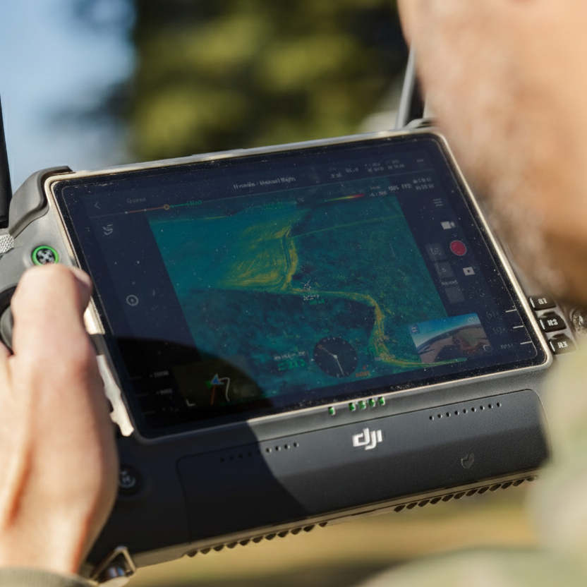
Multispectral imaging identifies stress, disease, and nutrient issues early—so you can act before yield is impacted.
Detailed aerial insights help you evaluate drainage, stand uniformity, problem areas, and overall field performance.
RTK-level maps and orthomosaics provide precise measurements for planning, documentation, and long-term land management.
Drone data for timber inventory, stand health, replant planning, and aerial seeding in hard-to-access areas.
Thermal surveys and aerial mapping support herd analysis, habitat improvement, and responsible wildlife management.
Aerial seeding and nutrient application help establish forage, repair thin areas, and improve grazing productivity.
Cover crop seeding, soil-health practices, and precision application designed to improve sustainability and long-term land value.
Lorem Ipsum is simply dumy text of the printing typesetting industry lorem ipsum.
Justfly is a powerful all-in-one camera drone designed for creators on the move. It offers a 1-inch CMOS sensor, 5.4K video recording, an innovative MasterShots feature, 12km 1080p video transmission, four-directional obstacle sensing, and more. Justfly 2S is the perfect way to turn any adventure into a stunning visual creation.
Jut and his company definitely go beyond to ensure his customers are taken care of. Whether it’s marketing, deer recovery, lost pets or people, Agricultural services…Jut has the ability to capture those moments! I watching him fly drones during a fireworks display to searching for lost animals. He loves what he does, he loves to get kids involved and his passion for your happiness is his reward…
Jut and the Captured Ag team came and did both liquid fungicide and later some vetch and clover cover crop...worked hard and fast and got it done efficiently
I wholeheartedly recommend them for wildlife, forestry and agricultural needs...
Oh yeah. He then can find your Big Buck in the swamp you cant track
We offer precision drone spraying, fertilizer and seed spreading, frost seeding, pasture renovation, and aerial mapping. Our services help farmers, horse operations, and landowners apply products accurately, efficiently, and on schedule.
Drone application is ideal when fields are too wet, crops are tall, terrain is uneven, or areas are difficult to access. It prevents soil compaction, crop damage, and delays that can impact yield or pasture quality.
Coverage depends on the product and application rate, but our fleet—including the T50 (Bumblebee) and T100 (Atlas)—allows us to efficiently treat large acreages quickly to keep your operation moving.
We can apply herbicides, fungicides, insecticides, liquid fertilizers, dry fertilizers, and seed for cover crops or pasture improvement. If you have a specific product in mind, we’re happy to confirm compatibility.
Yes. Our drones use GPS-guided precision technology to ensure even coverage and accurate application. We follow all FAA and agricultural regulations and prioritize safety, drift control, and proper documentation.
Call or text Jut Updyke at 757-705-2699 or visit www.allcaptured.com. We’ll discuss your goals, acreage, timing, and product needs to build a plan that fits your operation.